Groundsite Image Gallery
Kansas River scene

Kansas River from City Hall

86 Bends of the Kaw: Mile 0, Kaw Point: Kansas City, KS (two views)
86 Bends of the Kaw: Mile 5, Kansas City, KS, Wyandotte County
86 Bends of the Kaw: Mile 10-13, Muncie, Grinter Heights
86 Bends of the Kaw: Mile 13-23, Edwardsville, Bonner Springs

86 Bends of the Kaw: Mile 24-30, hairpin Curves between Coldspur and Cedar (three views)
86 Bends of the Kaw: DeSoto, looking back NE at the hairpin curves

86 Bends of the Kaw: Mile 31, DeSoto Bridge

86 Bends of the Kaw: Mile 35, Linwood, Weaver's Bottoms distant

86 Bends of the Kaw: Mile 37-43, Weaver's Bottoms (four views)
86 Bends of the Kaw: Mile 42.5, Eudora Bridge, jetties

86 Bends of the Kaw: Mile 44-49, east of Lawrence

86 Bends of the Kaw: Mile 47, angle bend east of Lawrence

86 Bends of the Kaw: Mile 50-54, Lawrence

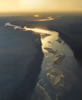
86 Bends of the Kaw: High altitude view of Lakeview oxbow (1891), Perry Reservoir distant

86 Bends of the Kaw: Scenic River Road, East of Lecompton

86 Bends of the Kaw: Mile 60-64, Scenic River Road, up to Lecompton

86 Bends of the Kaw: Mile 63-75, Lecompton Bridge
86 Bends of the Kaw: Mile 66-72, west of Lecompton (Delaware tributary)
86 Bends of the Kaw: Grover, Spencer

86 Bends of the Kaw: Tecumseh, Shunganungu Creek Mile 76
86 Bends of the Kaw: Mile 80, Northeast Topeka

86 Bends of the Kaw: Mile 84.5, West Topeka, I-75
86 Bends of the Kaw: Mile 90-100, Silver Lake (1873-1875)
86 Bends of the Kaw: Mile 102.5, Cross Creek, Rossville
86 Bends of the Kaw: St. Mary’s area

86 Bends of the Kaw: Mile 116, Lost Creek, Belvue

86 Bends of the Kaw: Mile 119-124, Vermillion Creek area

86 Bends of the Kaw: Mile 122-127, Wamego
86 Bends of the Kaw: Mile 129-135, cutoff near Wabaunsee
86 Bends of the Kaw: Mile 139-144, between St. George and Manhattan (two views)

86 Bends of the Kaw: Mile 147.5, Big Blue River from Tuttle Reservoir
86 Bends of the Kaw: Mile 150-154, McDowell Creek Road, Hunter’s Island
86 Bends of the Kaw: Eureka Lake area
86 Bends of the Kaw: Mile 159-163, Ogden
86 Bends of the Kaw: Mile 164-168, Fort Riley
86 Bends of the Kaw: Fort Riley, Milford Reservoir in distance
86 Bends of the Kaw: Up to Mile 170, The junction at Junction City (three views)
Bends of the Kaw-Big Springs (East of Lecompton Mile 60-65)

Bends of the Kaw-Big Springs (Delaware River enters from the North at Mile 64.5)
Bends of the Kaw-Big Springs (Braided stretch West of Lecompton Mile 66-70)
Bends of the Kaw-Big Springs (Near Grover, Spring Creek enters from the South at Mile 68.5)
Bends of the Kaw-Big Springs (North of Big Springs near DG/SN county line at Mile 70.5)

Five Bends of the Kansas River (Mile 24-30, hairpin turns near DeSoto)
Five Bends of the Kansas River (Mile 37-43, Weaver's Bottoms)

Five Bends of the Kansas River (Mile 47, Island east of Lawrence)
Five Bends of the Kansas River (Mile 150-154, along McDowell Creek road)
Five Bends of the Kansas River (Mile 164-168, bends near Fort Riley)
Kansas River-Weaver's Bottoms
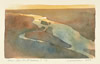
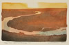
Kansas River-Serpentine

Bends Near Fort Riley
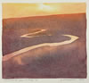
River Bend-East of Lawrence-June
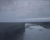
Gray Skies-Lower Kaw

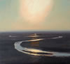
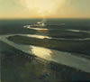
Kansas River-Moonlight
Kaw-Near the Delaware

Kaw-Near Vermillion Creek III
River Bends Near Fort Riley

Island at Mud Creek I
Foggy Kaw-East of Wamego
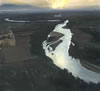
Flatwater

Kaw Island